
A storm system — possibly two — will likely bring the last part of that nightmare to life. An “early season storm system” is expected to strike as early as this afternoon. And it could possibly last into Friday, according to the National Weather Service.
Hope your Haley Quinn costume is water resistant.
This first front will be relatively warm for a storm. There will be heavy rain at times, forecasters believe, with as much as a half inch per hour in some areas.
“There will be the potential for moderate to heavy rainfall and thunderstorms as the storm taps into subtropical moisture and the remnant moisture from Hurricane Seymour,” according to the weather service. “San Luis Obispo and Santa Barbara counties will have the best chance of heavy rain and thunderstorms, but there is also the potential in Ventura and Los Angeles counties. Flash flooding, along with mud and debris flows, will be a concern with any thunderstorms or heavy rain, especially for recent burn areas.”
Forecasters are predicting as much as an inch of rain total in the L.A. basin, perhaps as many as two in some foothill areas. There is a slight chance of leftover rain again Saturday, with another front moving in Sunday that should slide above a drying out Southern California, they say.
The Auto Club of Southern California is urging drivers to be extra careful as the rain hits today and tomorrow. “This storm is expected to produce a lot of rain, so we’re reminding motorists that wet roads and cooler weather combine to significantly increase crash risk,” says the club’s traffic safety manager, Anita Lorz Villagrana. “As best they can, drivers should scan the roadways, avoid road debris and look out for disabled vehicles in reduced visibility conditions.”
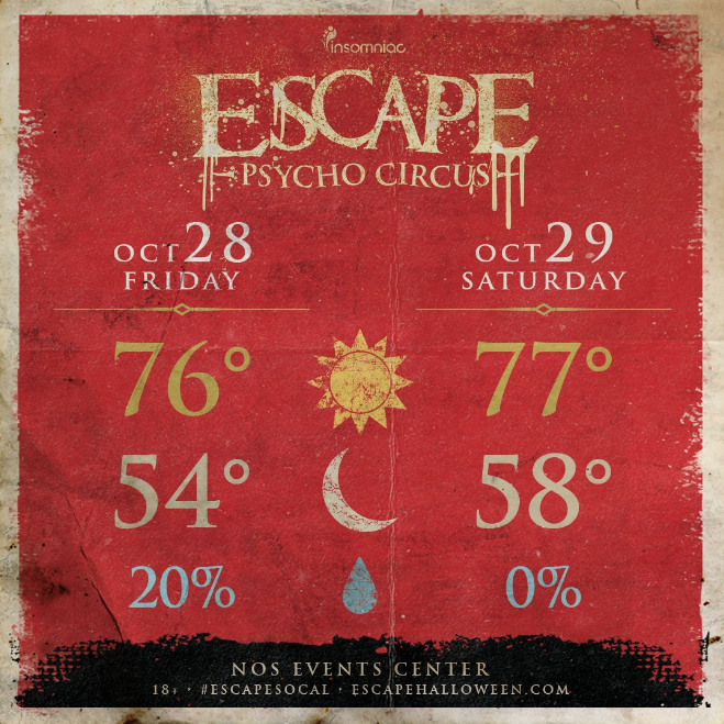
For those attending Escape on Friday and Saturday, here is your weekend Forecast – Mostly Sunny w/ a 100% of RAVE! Get wind of the weather & bring ur cloaks, capes+coats! It’ll get chilly.
Leave a Reply